A mixed-use development proposal along the Nall Avenue corridor recently required delineation of the shale bedrock surface beneath 35 feet of residual clay, a common challenge in Johnson County where the limestone and shale of the Kansas City Group create highly irregular weathering profiles. The geotechnical report indicated a potential paleochannel cutting through the site, and the only way to resolve it without excessive borings was a multi-line seismic tomography survey. Our approach integrates P-wave and S-wave refraction with high-resolution reflection to image the subsurface continuously, providing the engineering team with a 2D cross-section that pinpointed the bedrock trough within a 10-foot lateral resolution. This level of detail, which complements discrete SPT drilling data, allows structural engineers to optimize foundation design and avoid the cost overruns associated with unexpected rock excavation.
Seismic tomography resolves 10-foot lateral variations in bedrock depth that conventional borings on a 50-foot grid would simply miss.
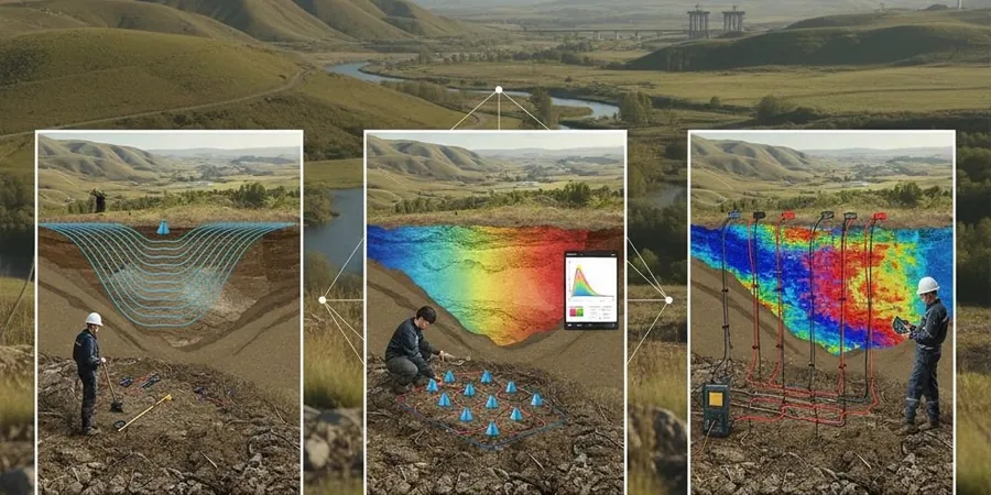
Methodology and scope
Local considerations
Johnson County sits on the northern fringe of the Cherokee Basin, where cyclic Pennsylvanian-age strata exhibit pronounced differential weathering: the Bethany Falls Limestone forms a competent caprock, while the underlying Galesburg Shale weathers to a soft, expansive clay. Seismic tomography directly addresses the risk of mischaracterizing the transition from stiff residual soil to highly weathered shale, a contact that SPT blow counts alone can misinterpret as competent rock. When the velocity profile shows a gradual increase from 3,000 ft/s to 7,000 ft/s over a 15-foot vertical interval, it signals a weathered zone that will degrade under repeated wet-dry cycles, potentially causing differential settlement in mat foundations. Karst features, though less common than in Missouri's Ozark region, have been documented in the Argentine Limestone near the Kansas River bluffs; a velocity inversion or diffraction hyperbola on a reflection record can indicate a solution cavity before it becomes a construction hazard. Overlooking these velocity anomalies risks sudden ground loss during excavation or long-term subsidence that compromises the building envelope.
Applicable standards
ASTM D5777-18 Standard Guide for Using the Seismic Refraction Method, ASCE 7-22 Minimum Design Loads (Site Classification based on Vs30), IBC 2021 Section 1613 (Earthquake Loads — Site Class Determination), ASTM D4428/D4428M-14 Crosshole Seismic Testing (for velocity calibration), KDOT Standard Specifications (when applicable for transportation corridors)
Associated technical services
P-Wave Refraction Tomography
The standard for bedrock mapping across Johnson County. We use 24- or 48-channel arrays with 5-foot geophone spacing to produce high-resolution compressional-wave velocity cross-sections, identifying the top of competent limestone or shale and locating buried paleochannels.
S-Wave Refraction Tomography
Essential for seismic site classification per ASCE 7-22. Horizontal geophones capture shear-wave arrivals, allowing direct measurement of Vs30 and identification of soft clay layers that standard P-wave surveys cannot distinguish from saturated soils.
High-Resolution Seismic Reflection
Deployed where vertical resolution of thin beds is critical, such as mapping individual limestone-shale couplets within the Kansas City Group for deep excavation planning or detecting voids beneath proposed heavy foundations.
Integrated Tomography & MASW
Combined P-wave refraction and multichannel surface wave analysis on the same spread, delivering a complete Vp and Vs model. This dual-parameter approach reduces interpretive ambiguity in the transition zone between weathered shale and competent rock.
Typical parameters
Frequently asked questions
How deep can seismic refraction tomography reliably investigate in Overland Park residual soils?
With a 16-pound sledgehammer source and a 250-foot spread, we typically achieve 80 to 100 feet of penetration in the silty clays and weathered shale common to Johnson County. For deeper targets, we use a trailer-mounted weight drop (100 to 400 lb) which can extend the investigation to 200 feet or more, depending on the velocity contrast between the weathered zone and competent bedrock. The tomographic inversion method provides better resolution at depth than traditional delay-time interpretation.
Can seismic reflection surveys detect karst cavities in the Argentine Limestone?
Yes, under favorable conditions. Cavities represent a sharp acoustic impedance contrast that generates diffraction hyperbolas on the stacked reflection section. We configure the survey with a dominant frequency above 150 Hz to resolve features in the 3-foot diameter range. The success rate depends on the depth-to-diameter ratio and the degree of water saturation, and we always recommend ground-truthing any interpreted anomaly with targeted drilling before making design decisions.
What is the typical cost range for a seismic tomography survey in Overland Park?
For a standard refraction tomography survey covering 500 to 1,200 linear feet with 24-channel acquisition and tomographic processing, the cost typically ranges from US$2,330 to US$5,750 depending on the number of spreads, the accessibility of the terrain, and whether S-wave data or reflection profiling is included in the scope.
How does seismic tomography compare to MASW for site classification per IBC?
Both methods can measure Vs30, but they measure different physical properties. MASW directly analyzes Rayleigh wave dispersion and is excellent for layered soil profiles. Refraction tomography provides a continuous 2D image of both P and S velocities, which is superior when the bedrock surface is highly irregular or when lateral velocity variations exist. For complex sites in the Kansas City Group geology, we often deploy both methods on the same spread: MASW for the Vs30 determination and refraction tomography for the bedrock and lateral heterogeneity mapping.